


Ocean currents are directed, continuous movements of ocean water. They are found on the ocean’s surface and in its depths, and can be local or global. Ocean currents are driven by winds, water density, and tides. Sea floor features and coast lines can influence the speed and direction of currents.
To better understand climate zones & ocean currents…
LET’S BREAK IT DOWN!
Coriolis Effect
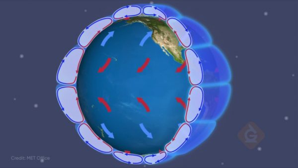
The Coriolis effect is a global wind pattern that is caused by the rotation of Earth, which rotates on its axis every 24 hours. Because of the rotation and tilt of Earth’s axis, certain latitudes move faster than others. For example, the North and South poles have less distance to move to make a complete rotation and are moving at a slower rate. The Equator has the furthest distance to move and is moving at the fastest rate. As air currents move from one latitude to another, they begin moving at the same rate of speed as their point of origin. However, the latitude that they are moving towards may be moving faster or slower. Consequently, the air currents “bend” because the Earth under them is moving at different rates. Air currents are deflected to the right in the Northern Hemisphere and to the left in the Southern Hemisphere.
Light Intensity
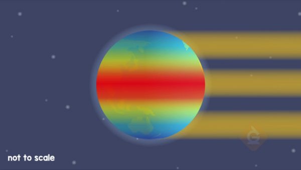
Light intensity measures how much energy is hitting a surface. Light travels in a straight line until it hits something else that may block or reflect the light in a different direction. When light travels in a straight line from the Sun to Earth and hits its surface at a 90° angle, it is the most intense and transfers the most energy (solar radiation). When light hits the surface of Earth at a smaller angle, less energy and solar radiation is transferred because the light is spread out over a larger area of Earth’s surface.
Tropical Zone
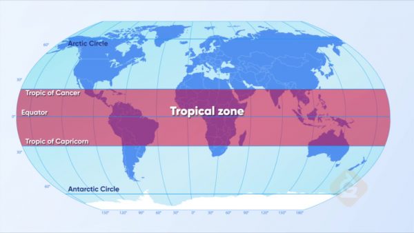
The Tropical Zone is the region of Earth found in the middle of the globe. This climate zone can be found between the latitude lines of the Tropic of Cancer and the Tropic of Capricorn. This zone accounts for 36% of Earth’s landmass and is home to about a third of the world’s people.
The Tropical Zone is warm all year, averaging 25 to 28 degrees Celsius (77 to 82 degrees Fahrenheit) because it gets more exposure to the Sun. Because of all that sun, the tropics don’t experience the kind of seasons the rest of Earth does; there are just two: the wet season and the dry season.
Temperate Zone

The Temperate Zone is the region of Earth found between the Tropical Zone and the Polar Zones. The Temperate Zone is sometimes called the mid-latitudes because they exist roughly between 30 degrees and 60 degrees north and south latitude. There is a greater variety of climates in the Temperate Zone—those areas near oceans have much different climates than those that are found in the middle of large land masses.
Polar Zone
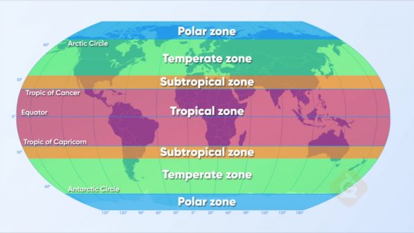
The Polar Zones are the regions that extend from 66.5 degrees north and south latitude to the North and South Poles. Within each polar zone are two distinct subregions, the ice cap and the tundra. The north and south polar regions are very different. The north is dominated by the Arctic Ocean, and it is dotted by islands belonging to several different nations. The south is the continent of Antarctica which is one large landmass that doesn’t belong to any nation.


 Select a Google Form


 GENERATION GENIUS