Reading Material
1%
It was processed successfully!
WHAT IS A COORDINATE PLANE?
A coordinate plane is a two-dimensional number line where the vertical line is called the y-axis and the horizontal is called the x-axis. You can use these two number lines to place points, or ordered pairs of numbers.
To better understand the basic coordinate plane…
WHAT IS A COORDINATE PLANE?.
A coordinate plane is a two-dimensional number line where the vertical line is called the y-axis and the horizontal is called the x-axis. You can use these two number lines to place points, or ordered pairs of numbers.
To better understand the basic coordinate plane…
LET’S BREAK IT DOWN!
Amusement Parks

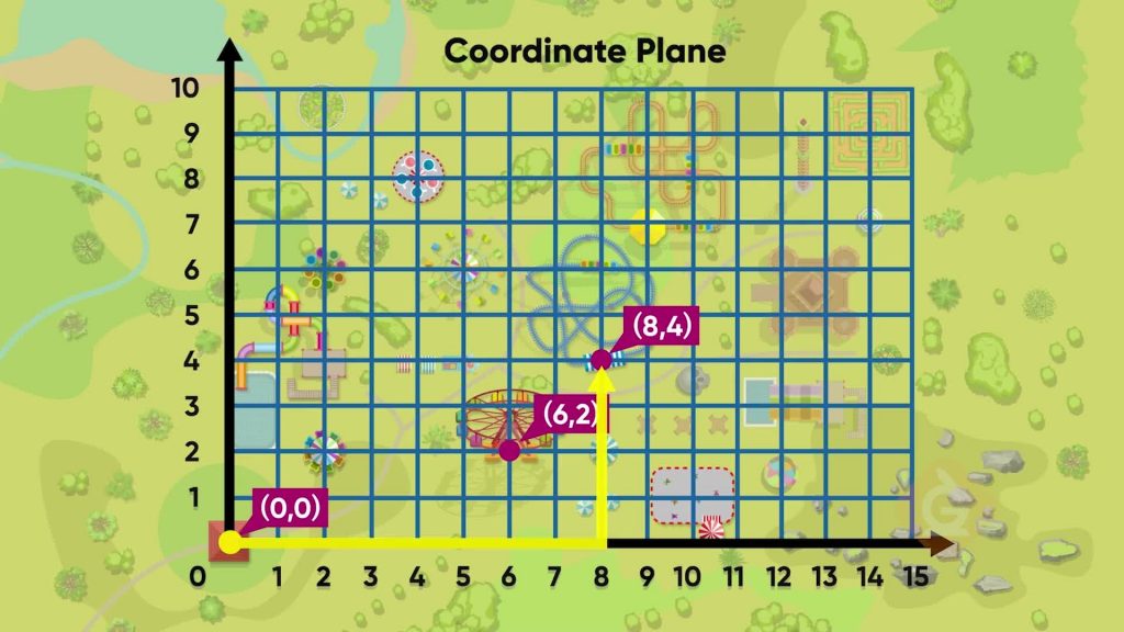
Let's say you want to navigate an amusement park by using a coordinate grid to locate different rides. A coordinate grid is a pair of two number lines that intersect. One is horizontal and one is vertical. The horizontal number line is called the x-axis. This number line gives the x-coordinate of the location of a ride. The vertical number line is called the y-axis. This number line gives the y-coordinate of the ride's location. The coordinate grid can give the exact location by assigning that location a point called an ordered pair. To locate any place on the map, begin at the origin. The origin is at (0, 0). Count units right of the origin and up from the origin for each ride. The path to the Ferris wheel from point (0, 0) is 2 units to the right along the x-axis and 3 units up along the y-axis, so it is at the point (2, 3). The location on the x-axis always goes first in the pair. The roller coaster is located 8 units to the right along the x-axis and 4 units up along the y-axis from the origin. The roller coaster is at point (8, 4). Try this one yourself: The haunted house is located 10 units to the right of the origin along the x-axis and 7 units up along the y-axis. What ordered pair do we assign to the haunted house?
Amusement Parks Let's say you want to navigate an amusement park by using a coordinate grid to locate different rides. A coordinate grid is a pair of two number lines that intersect. One is horizontal and one is vertical. The horizontal number line is called the x-axis. This number line gives the x-coordinate of the location of a ride. The vertical number line is called the y-axis. This number line gives the y-coordinate of the ride's location. The coordinate grid can give the exact location by assigning that location a point called an ordered pair. To locate any place on the map, begin at the origin. The origin is at (0, 0). Count units right of the origin and up from the origin for each ride. The path to the Ferris wheel from point (0, 0) is 2 units to the right along the x-axis and 3 units up along the y-axis, so it is at the point (2, 3). The location on the x-axis always goes first in the pair. The roller coaster is located 8 units to the right along the x-axis and 4 units up along the y-axis from the origin. The roller coaster is at point (8, 4). Try this one yourself: The haunted house is located 10 units to the right of the origin along the x-axis and 7 units up along the y-axis. What ordered pair do we assign to the haunted house?
Class Trip

Let's say you have a map to help you find different destinations on your class trip to Centerville. Each of the destinations has been assigned an ordered pair to help you find it on the coordinate grid for Centerville. Your hotel is at the intersection of Main Avenue and Main Street. Make this the origin, or the point (0, 0). Next, let the x-axis represent the streets and the y-axis represent the avenues in Centerville. The museum is located at point (7, 2), or 7 streets to the right along the x-axis and 2 avenues up the y-axis. The fountain is located at point (3, 5). Go 3 streets to the right along the x-axis and 5 avenues up along the y-axis to find the fountain on the map. The skate park is located at point (0, 6). Move zero streets to the right on the x-axis and 6 avenues up on the y-axis. Try this one yourself: On the Centerville Map, the Historical Society Building is located at point (9, 0). How do you get to the Historical Society Building from the hotel?
Class Trip Let's say you have a map to help you find different destinations on your class trip to Centerville. Each of the destinations has been assigned an ordered pair to help you find it on the coordinate grid for Centerville. Your hotel is at the intersection of Main Avenue and Main Street. Make this the origin, or the point (0, 0). Next, let the x-axis represent the streets and the y-axis represent the avenues in Centerville. The museum is located at point (7, 2), or 7 streets to the right along the x-axis and 2 avenues up the y-axis. The fountain is located at point (3, 5). Go 3 streets to the right along the x-axis and 5 avenues up along the y-axis to find the fountain on the map. The skate park is located at point (0, 6). Move zero streets to the right on the x-axis and 6 avenues up on the y-axis. Try this one yourself: On the Centerville Map, the Historical Society Building is located at point (9, 0). How do you get to the Historical Society Building from the hotel?
Treasure Maps

Let's say that you have a treasure map. A set of coordinate points on the map form a geometric shape. There is a buried treasure located within that shape. Plot the coordinates to form the shape and locate the buried treasure. The first coordinate on the treasure map is (2, 1). Start at the origin and go 2 places right on the x-axis and up 1 on the y-axis and mark that point. The next point is (5, 5). Go 5 right and up 5 from the origin. The last point to mark is (7, 1). Go 7 to the right and 1 up from the origin. Connect the three points to make a triangle. The treasure is inside the triangle. Now let's say another treasure is buried inside the shape made by the coordinates (3, 3), (6, 3), (3, 9), and (6, 9). Plot each point by going right the number in the x-coordinate position and up the number in the y-coordinate position. Connect the points to form a rectangle with treasure inside of it. Try this one yourself: On a map of Main St. School, a time capsule is buried inside the shape formed by the coordinates: (4, 2), (4, 7), (10, 2), and (10, 7). What shape is formed?
Treasure Maps Let's say that you have a treasure map. A set of coordinate points on the map form a geometric shape. There is a buried treasure located within that shape. Plot the coordinates to form the shape and locate the buried treasure. The first coordinate on the treasure map is (2, 1). Start at the origin and go 2 places right on the x-axis and up 1 on the y-axis and mark that point. The next point is (5, 5). Go 5 right and up 5 from the origin. The last point to mark is (7, 1). Go 7 to the right and 1 up from the origin. Connect the three points to make a triangle. The treasure is inside the triangle. Now let's say another treasure is buried inside the shape made by the coordinates (3, 3), (6, 3), (3, 9), and (6, 9). Plot each point by going right the number in the x-coordinate position and up the number in the y-coordinate position. Connect the points to form a rectangle with treasure inside of it. Try this one yourself: On a map of Main St. School, a time capsule is buried inside the shape formed by the coordinates: (4, 2), (4, 7), (10, 2), and (10, 7). What shape is formed?
Vacation Weather

Let's say that you are planning a vacation and would like to know how the weather will change throughout the week. One way to do this is to graph data from a table of daily temperatures on a coordinate grid. The points on the graph tell a story. Make ordered pairs from the table of data. Let's say the table consists of days of the week and each day's temperature. We can assign the days of the week as x-coordinate values and label them 1 through 7. Next we have the daily temperatures from Monday to Sunday as follows: 17°C, 18°C, 20°C, 21°C, 23°C, 24°C, and 26°C. These are the y-coordinate values. Write each day and its temperature as an ordered pair as follows: (1, 17), (2, 18), (3, 20), (4, 21), (5, 23), (6, 24), and (7, 26). Next, plot these points on the coordinate grid and connect all of the points. The graph of the data shows us a trend: the line goes up to the right, so the temperature gets warmer each day. Try this one yourself: Let's say you graph how much money you have left to spend on vacation by graphing each day and the amount of money in your pocket. The ordered pairs are (1, 200), (2, 150), (3, 100), (4, 75), (5, 50), (6, 25), (7, 0). What trend do you see?
Vacation Weather Let's say that you are planning a vacation and would like to know how the weather will change throughout the week. One way to do this is to graph data from a table of daily temperatures on a coordinate grid. The points on the graph tell a story. Make ordered pairs from the table of data. Let's say the table consists of days of the week and each day's temperature. We can assign the days of the week as x-coordinate values and label them 1 through 7. Next we have the daily temperatures from Monday to Sunday as follows: 17°C, 18°C, 20°C, 21°C, 23°C, 24°C, and 26°C. These are the y-coordinate values. Write each day and its temperature as an ordered pair as follows: (1, 17), (2, 18), (3, 20), (4, 21), (5, 23), (6, 24), and (7, 26). Next, plot these points on the coordinate grid and connect all of the points. The graph of the data shows us a trend: the line goes up to the right, so the temperature gets warmer each day. Try this one yourself: Let's say you graph how much money you have left to spend on vacation by graphing each day and the amount of money in your pocket. The ordered pairs are (1, 200), (2, 150), (3, 100), (4, 75), (5, 50), (6, 25), (7, 0). What trend do you see?
UNDERSTANDING THE BASIC COORDINATE PLANE VOCABULARY
Coordinate Plane
A two-dimensional number line where the vertical line is called the y-axis and the horizontal is called the x-axis.
Coordinate Grid
A grid that is used to locate points using an ordered pair of numbers.
x-axis
The number line that is horizontal on a coordinate grid.
y-axis
The number line that is vertical on a coordinate grid.
Origin
The point where the two axes of a coordinate grid intersect; the point represented by the ordered pair (0, 0).
Ordered Pairs
A pair of numbers used to locate a point on a coordinate grid.
The first number in an ordered pair, which names the distance to the right or left from the origin along the x-axis.
The second number in an ordered pair, which names the distance up or down from the origin along the y-axis.
UNDERSTANDING THE BASIC COORDINATE PLANE DISCUSSION QUESTIONS
Why does the order in an ordered pair matter?
It tells me that first I need to 'go right x units and then up y units.' If I 'go right y units and then up x units,' this is a completely different location.
How can connecting the points on a graph of a real-world situation help us?
It helps us to see patterns and trends.


 GENERATION GENIUS


x
Choose Your Free Trial Period
Get 30 Days Free
By inviting 4 other teachers to try it too.
Skip, I will use a 3 day free trial
Thank You!
Enjoy your free 30 days trial